WP1 Drains
WP-leader: Bo Vangsø Iversen
Approximately half of the agricultural area in Denmark is artificially drained in order to lower the water table and prevent water logging. Drain pipes change the natural hydrology of the system and acts like short cuts for water and nitrate, transporting it directly to surface waters. Less nitrate is thereby transported below the redox interface and removed by reduction.
The drain dynamics are complex and vary in both space and time making it challenging to quantify the impact of drains. Furthermore, maps of existing drain pipe installations are often unreliable or unavailable. Knowledge on how to locate drainage networks and quantify the spatio-temporal drain dynamics is thus required. In TReNDS scientists will work with the following two hypotheses:
Hypothesis A: Drain pipe location can be reliably estimated at local scale by use of optimized ground penetrating radar (GPR) or aerial imagery and for national screening purposes by combining multiple digitalized maps and hydrological model simulations.
Hypothesis B: Improved quantification of drainage system impact on sub-catchment nutrient fluxes can be obtained by field tracer tests and high-resolution local data on soils/geology by multilayer electromagnetic induction (EMI) combined with hydrological models.
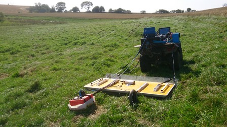
GPR measurements to detect the location of drain pipes. Photo by: Rambøll
|